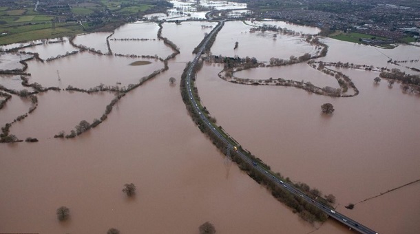
People of Britain are warned to prepare for ” disruption to transport and power supplies” by snow and flooding. / UK News
Up to 40cm of snow was expected over high ground in the Midlands, north and east of Wales and northwest England, with 10-15cm in lower lying areas.
Heavy snow was also expected in Northern Ireland with up to 30cm predicted across the hills of counties Antrim and Down, with high winds leading to blizzard conditions.
The snow is expected to continue into Saturday with the Met Office saying another 5-10cm was possible in some areas of central Britain.
It prompted the Met Office to issue two amber warnings for snow, meaning that the public in some places should be prepared for “severe disruption, particularly to transport and power supplies”.
More than 40,000 homes and businesses in Northern Ireland are without power because of storm force winds and snow. Around 60 schools have also been closed
Belfast George Best City Airport said its runway was closed, while Belfast International Airport warned that the weather could cause some disruption to flights.
Leeds Bradford International Airport has suspended all flights due to “adverse weather conditions”.
The airport has told passengers: “We advise you contact your airline or tour operator and check the status of your flight before arriving at the airport.”
Heavy overnight snow has caused severe traffic problems and school closures across West Yorkshire.
Among the main roads affected in the region are the A1(M) between the end of the M1 and the A62 junction, between Leeds and York, where snow has closed a lane, and the M62 near Brighouse, where another lane has been closed due to the weather.
Dozens of schools closed across Yorkshire, Derbyshire and Nottinghamshire.
Shops and homes were flooded in Cornwall overnight, as the AA warned motorists even short journeys “can quickly turn bad”.
In addition, there were 96 flood warnings in place across the country, with southwest England the worst affected.
Seventeen flood warnings, meaning flooding is expected, were in place, affecting Devon and Dorset.
And 79 flood alerts, where flooding is possible, were in place across the South East and Midlands, but the South West is likely to be the hardest hit.
Police said they received a “significant” surge in call-outs on Thursday evening in the South West.
Sgt Dave Opara, based in Plymouth, said: “There has been a considerable amount of rainfall across the force area.”
Cornwall opened its dedicated control centre to deal with the volume of calls about flooding. Fire crews had already been called out to 50 incidents before 10pm on Thursday.
Newlyn, in the southwest of the county, was reported to be the worst affected area.
Newlyn resident Adam Gibbard said the river through the town had burst its banks and swept into the main street.
“This is the second time it has happened in three months and a lot of these properties are businesses who were just getting back on their feet,” he told Sky News.
“It has been very heavy rain all day and the deepest areas are a couple of feet deep.
“There are a lot of people out with sandbags, there are a lot of fire crews, people pitching in and trying to stem it but I don’t think they have much of a chance.”
Britain Flood Warnings:Environment Agency Warned about rain for every UK zones
Environment Agency spokesperson Pete Fox said: “Heavy rain in southwest England and south Wales on Thursday and into Friday means there is a risk of localised surface water and river flooding in the south west, the southern counties and parts of south Wales.
“Over the next 24 hours, central parts of the UK will be most at risk of significant snow, particularly Northern Ireland, southwest Scotland, northwest England, northeast Wales and the north Midlands.
“There will be drifting in the raw wind and blizzard conditions. Disruption is likely to transport and perhaps even power supplies.”
Darron Burness, head of the AA’s Special Operations Response Team, said: “It’s going to be a real witch’s brew of driving wind, rain and snow, which will inevitably cause disruption on the roads.
“Drivers should be well prepared as even short journeys can quickly turn bad.
“Drifting snow could repeat the scenes we saw in southern England last week when hundreds of drivers got stuck overnight – it only takes one or two vehicles struggling for grip for the situation to quickly escalate.
“Keep your speed down as visibility could be seriously reduced and there’s a risk of localised flooding – just stay out of flood water.
“Also with temperatures set to remain low, any snow that settles will likely persist for several days, so be wary of icy patches.
“Wherever you’re going, take plenty of warm layers, check the travel reports before heading out and stick to the main roads where possible.”
The Local Government Association said council gritting and ploughing teams would be out in force to try to ensure main roads remained passable.
Britain Flood Warnings:Cornwall flood video
[media id=861 width=610 height=340] [adrotate banner=”60″]


